
DATA CURATION
This page provides all information about the CRD data management process.
Climate Risk Database data curation process is built on CRD data quality standards. All stakeholders involved in the data lifecycle works together to achieve highest possible quality for the produced data.
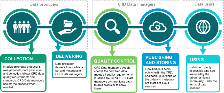
DATA PROVIDERS
In Tanzania’s Urban Resilience Program, data providers collect geospatial data from various projects to generate crucial information about climate-related risks. For all datasets published on the Climate Risk Database, they must meet specific quality standards, including relevant attributes, geometrical connectivity, and standardized metadata.
CRD DATA MANAGERS
CRD Data managers are responsible for quality controlling all datasets, supporting data providers, and sharing published datasets on social media. Their contact information is on Climate Risk Database | Community Groups | Data Managers, and training materials are on Digicampus platform (Gmail-registration required).

DATA USERS
Data users is the whole community who benefits from the datasets published in Climate Risk Database. Data users are, for example, local citizens, NGOs, urban planners, researchers, education institutes and all other stakeholders within the field of urban resilience and disaster risk management.
Climate Risk Database (CRD)
Recilience Academy’s Climate Risk Database (CRD) is a geospatial data repository that supports research, education and planning, such as disaster-risk management practices. The rich repository of datasets consists of open-access data from industrial training, Tanzania Urban Resilience Program projects, and third parties.
CRD is built on open-solution platform of Geonode, hosted at the University of Turku Geonode.
We curate Climate Risk Database, a open-access repository with a collection of geospatial data on urban resilience and disaster risk management in Tanzania
Data curation skills
We develop and conduct training for the next generation and professional experts to enhance their practical skills and academic understanding of urban challenges. We provide contact learning and online courses for University experts, government officials, University students and other professionals interested in improving their digital data skills.
We also develop digital geospatial data quality and management skills of young professionals and students in universities and partner organizations.
Tools
We have collected a repository of useful open-access tools and practices with instructions for geospatial data management. Most of the tools are available through QGIS software, that anyone can download without fees. You can use the tools for data editing, quality assessment and other management practices.
We maintain a list of useful open-access tools suitable for digital data collection, management and analysis. We train students with these tools in the industrial training and courses at Tanzanian universities.
Data Visualisation Challenge
The visualisation competition is for university students interested in developing their digital data visualisation skills. Students learn together and work in groups to create powerful data visualisation solutions for the needs of real world.
In their work, students use data that is shared in Climate Risk Database.
We organize annually Data Visualization Challenge, which gathers enthusiastic students from Tanzanian universities to compete in teams and pitch for their best geospatial data visualization solution.
DATA QUALITY STANDARDS
Climate Risk Database (CRD) of the Tanzania Resilience Academy shares open datasets related to urban resilience in Tanzania. All datasets shared via CRD follow the data quality standards identified and described on this page. By defining data quality standards, we can assure that the data has high-quality accessibility and usability for the urban resilience community and Tanzania Urban Resilience Program partners.
Join to us to make use of data
Access to digital data sets is a pre-requisite for understanding risks and developing evidence-based solutions for resilient urban development”