
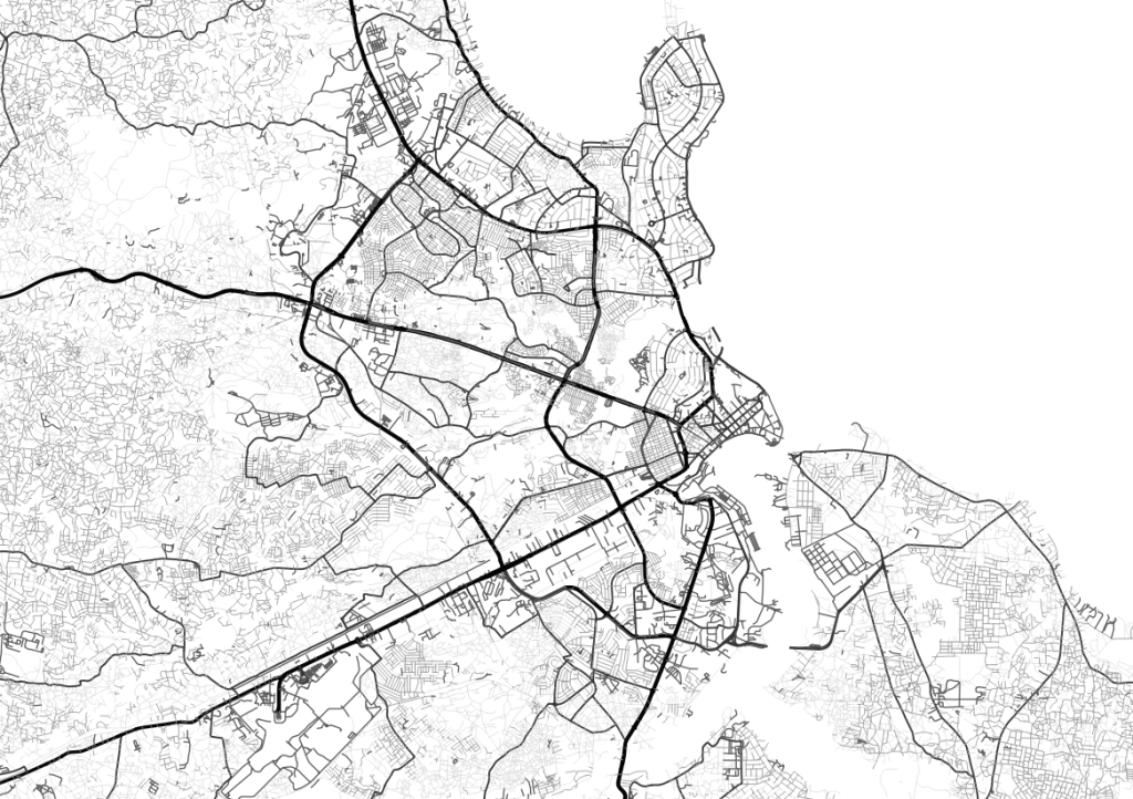
Dar es Salaam Roads 2022 -dataset has been produced as a part of the World Bank’s project for urban development in Tanzania. This 2022 dataset is an update to an older version of 2019 and includes estimated average road reserve width for different road classes in the city of Dar es Salaam. Estimated widths of the roads have been based on city-wide observations of satellite imagery.
This dataset has been curated by our group as a part of the Geospatial data management and visualization course in the University of Turku. We started by collecting all given information in the metadata and in the dataset. Next, we identified any gaps in information. Afterwards, we interviewed the contact person who has been involved in the data creation process and asked about the missing and unclear information. Based on the information we were given, we filled in the missing information and checked the overall quality of the dataset in detail by a set of tools in QGIS and curated the dataset the best we could. Most of our questions were answered and corrected in the meta dataset but some flaws remain unanswered.
The dataset has a few weaknesses that are to be considered when utilizing it. All compulsory metadata fields, except for date of creation, were provided. Firstly, columns named “Surface” and “name” have missing values that have not been provided with any explanations. The temporal extent of the dataset remains partly a mystery since only the year 2022 has been provided in the title, without details clarifying the exact dates or months. Additionally, the route data has mostly good connectivity, but some issues (78 errors), where parts of the road were missing, were found. Most of these errors are located within the borders of Dar Es Salaam. The absolute location of the roads is accurate when compared to Open Street Map. However, at times slight differences and abnormalities are found when compared to satellite imagery.
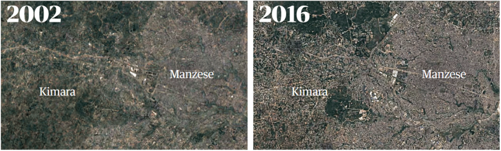
This dataset is fascinating because it provides a semi-complete set of spatial data about relatively difficult road network to map. In addition, this kind of data is crucial when it comes to providing essential services in rapidly expanding cities like Dar es Salaam. Struggling to find solutions related to problems with exponential city growth, the city of Dar es Salaam has had to find technical solutions to issues like traffic congestion and sustainable public transportation. GIS along with sufficient datasets can provide opportunities regarding city planning processes and optimization of existing networks.
The article “Untying Dar es Salaam’s Traffic Knots, One Feeder Road at a Time” tells, how Dar es Salaam Metropolitan Development Project (DMDP) has been successful at reduce traffic and time of the journeys especially during peak traffic hours by utilizing newly paved roads, improvements to the local and feeder road networks and better management of the traffic hotspots (The World Bank, 2019). This kind of intervention has been possible after identifying the most congested parts of the road networks. This is the process where high-quality and up-to-date spatial datasets can offer great opportunities, for example, by enabling high quality network analysis or mapping of different phenomena related to transportation.
In the article “How an emerging African megacity cut commutes by two hours a day”, written in 2019 in The Guardian, the public transportation has been described as “virtually no public transport”. Dar es Salaam has chosen to build a less cheap option than a metro: the bus. They have built the DART system, which is a major public transportation initiative and has been designed to improve urban mobility and reduce the commute time in the city of Dar es Salaam. The DART system was developed in response to the growing traffic congestion and long commuting time. It has improved accessibility for unreachable areas, reduced pollution, had positive economic impacts, and enhanced residents’ quality of life by providing more efficient public transportation.
In the article “A Review of Traffic Congestion in Dar es Salaam City from the Physical Planning Perspective”, written by Kiunsi, has been presented one of Dar es Salaam’s major problems, traffic congestion, has been presented. Traffic congestion is resulted by rapid population increase, inadequate and poor road infrastructure, unplanned city structure and development and rapid increase of the number of cars. Traffic congestion has led to different socio-economic and environmental impacts. The biggest strategies to control the traffic congestion are increasing road capacity as well as improving the public transportations services. However, these strategies have not been successful due to the rapid increase of population and cars as well as lack of physical planning to reduce traffic congestion. To improve the situation of both road capacities and public transportation should be applied together with physical planning.
Articles mentioned in the previous paragraphs underline well why datasets like Dar es Salaam Roads 2022 are so important. They enable higher quality city planning and better management of the numerous challenges related to rapid growth of the cities. With relatively sufficient datasets like Dar es Salaam Roads 2022, it is possible to identify, for example, the most congested areas of the city or the areas that critically need upgrades to work properly. Additionally, with datasets of good quality it is possible to calculate coverage and accessibility of public transportation networks, which can help to boost economic activity in a city. The importance of using GIS methods for city development has also been mentioned in the abstract of the World Bank’s Dar es Salaam Metropolitan Development Project.
By these examples, we would like to convey the idea that high quality datasets are highly important, because ultimately their impact can be seen all around us in the environments that we, the people, are living in.
The dataset is now available at Resilience Academy’s Climate Risk Database as Dar Es Salaam Roads 2022.
References:
The World Bank, 2019. Untying Dar es Salaam’s Traffic Knots, One Feeder Road at a Time. 29.9.2023. <https://www.worldbank.org/en/news/feature/2019/04/01/untying-dar-es-salaams-traffic-knots-one-feeder-road-at-a-time>
The Guardian, 2019. How an emerging African megacity cut commutes by two hours a day. 8.1.2019. Accessed 29.9.2023. <https://www.theguardian.com/cities/2019/jan/08/how-an-emerging-african-megacity-cut-commutes-by-two-hours-a-day-dar-es-salaam>
Kiunsi, R.B. 2013. A Review of Traffic Congestion in Dar es Salaam City from the Physical Planning Perspective. Journal of Sustainable Development, 6, 94. DOI:10.5539/JSD.V6N2P94